Powering Innovative Solutions
Set forth below are some of our key technology related initiatives:
TransAnalyst
We are developing TransAnalyst in-house as a geographic information system (GIS)-backed planning and analytics tool which is expected to aid us in the planning of power transmission lines. The platform suggests the least cost/ optimum route by considering all geological and regulatory constraints. This is of great importance to the project management team to avoid frequent manual interventions and corresponding delays. TransAnalyst provides benefits of reducing time, accuracy of digital data, iterative capability, minimising manual intervention and data driven decision making.
Hydrology Studies
Transmission lines are built with the objective of ensuring reliable power delivery to the consumers over lifespan of the lines. Major challenges are faced to ensure reliability of transmission towers in areas of river crossings, streams and water bodies because of continuous change in direction of river flow over a time-period. In order to ensure that transmission towers remain intact with river flow, scour protections are used on tower foundations.
Conventional method of identifying towers which are close to river path and to design scour protection is to use toposheets and Google imagery. Also, slope of terrain is calculated using manual calculations and toposheet. The conventional method is a manual process, is time consuming and prone to errors.
In order to eliminate challenges posed by conventional methods, we are using satellite imagery, digital elevation model and hydrology modelling tool to identify the pattern of river flow. The use of satellite imagery leads to accuracy in modelling river flow and identification of scour protection.
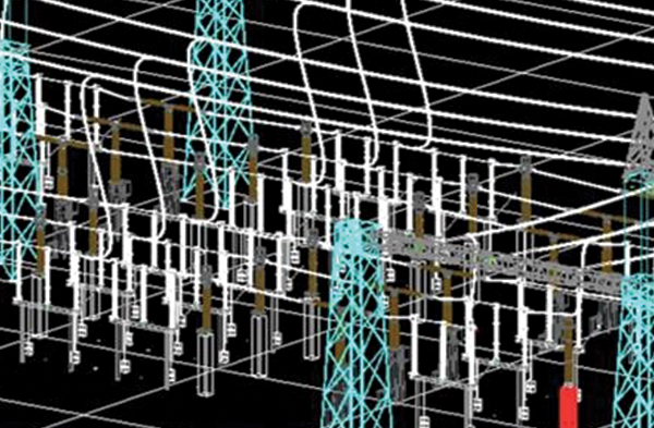
Building Information Modeling
Building Information Modeling
For substation designing, we utilise 3D design and 4D construction methodologies, which provide the benefits of faster, data-driven decision making, avoiding project delays, better safety planning and better planning for regulatory clearances.
Satellite Imagery ― Digital Terrain Model
One of challenges faced in the delivery of transmission projects is the variance in route profiles during the project construction stage due to non-availability of good resolution and accurate terrain data through conventional survey methods.
Conventional survey methods typically require longer to collect terrain data for route profiling and are intensive manual processes. This may also lead to inaccurate terrain data and variance in route profile during project construction, leading to loss of time in project.
Owing to challenges faced in route profiling, we are moving towards utilising high resolution satellite imagery for creating terrain data for route profiling. Route profiles created using high resolution satellite imagery are generally more accurate and less time consuming, leading to saving of time in project.
CDC
Containerised Data Centres (CDC) is a plug-and-play edge data-centre solution for telcos, designed to allow them to accelerate their time to market, improve response time and uplift the overall customer experience.
Ster-Eco
This conductor has been specially designed for addressing the losses during renewable energy transmission. Also known as ‘low-loss conductor’, it contributes to lowering emission of greenhouse gases, has inherent strength and high concentration of aluminum in the define diameter. It can reduce I²R losses in the transmission line by up to 30% compared to a same size conductor. This product is environment-friendly and helps in reducing carbon emissions.
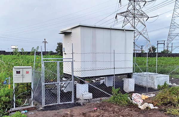
CDC with Fencing
Multi circuit towers
PVT
DG Sets are one of the primary sources to power telecom antennas, especially in areas where uninterrupted power is unavailable. We have come up with the solution of using power voltage transformers (PVTs) to directly tap power from the extra high-voltage transmission lines and power telecom antennas hosted on transmission towers. This helps in reducing carbon-footprint in the environment.
Multi-Circuit
Implementation of multi-voltage multi-circuit towers is intended to enable us to minimize the physical footprint in the forest/wildlife areas.
NER - Helicopter use
We used lightweight helicopters to transport large volumes of materials across various locations. This allowed us to overcome hilly terrains, inaccessible remote locations and restrictions imposed due to the COVID-19 lockdown.
Information Technology
Our technology systems encompass digital platforms, enterprise applications, cyber security tools, all hosted over a hybrid infrastructure stack, including a private cloud for the core ERP and public cloud for our evolving digital footprint. Digitisation is one of our key pillars for IT and, with this in mind, we have invested in building multiple applications as part of an integrated ecosystem to bring about efficiency and optimisation. Few examples of core processes that have undergone digital transformation include business acquisition – the bidding stage in which our transmission routes are generated through an in-house developed digital platform for route prediction. Further, our “CanvasR” application is used for pre-bid surveys to capture and share in-field observations in real time to finalise the most efficient route.
Our “Right of Way” application aims to reduce the land acquisition turnaround time and support a documentation framework for land documents. Similarly, the Quality Audit application aims to track and monitor compliance of all CTQs during tower setup and ensure early identification and redressal of any non-compliance issues. Our core project execution is tracked on platforms to enable high performance project delivery.
Our sales processes are executed digitally on our Salesforce CRM platform, empowering the sales and commercial excellence teams to manage the sales pipeline and drive productivity with a digital channel available to them on both web and mobile app. We leverage SaaS based applications to run processes that support our core business.